Views from Samuel Spiker’s 1833 Guide to Berlin
Table of Contents
- Introduction
- Die Grüne Wiese
- Schinkel’s Berlin
- Panorama and Diorama
- Spiker’s Guide to Berlin
- Conclusion
- Footnotes
Introduction
In 1833, George Gropius published one of the first illustrated guides to Berlin, entitled Berlin und seine Umgebungen im neunzehnten Jahrhundert (Berlin and its environs in the nineteenth century). The guide, written by the journalist, travel writer and librarian Samuel Heinrich Spiker, is a consolidation of the urban transformations of the decades following the Napoleonic Wars. The engravings in the guide reflect the changing experience of urban space and have set a standard for the visual representation of the city to date.
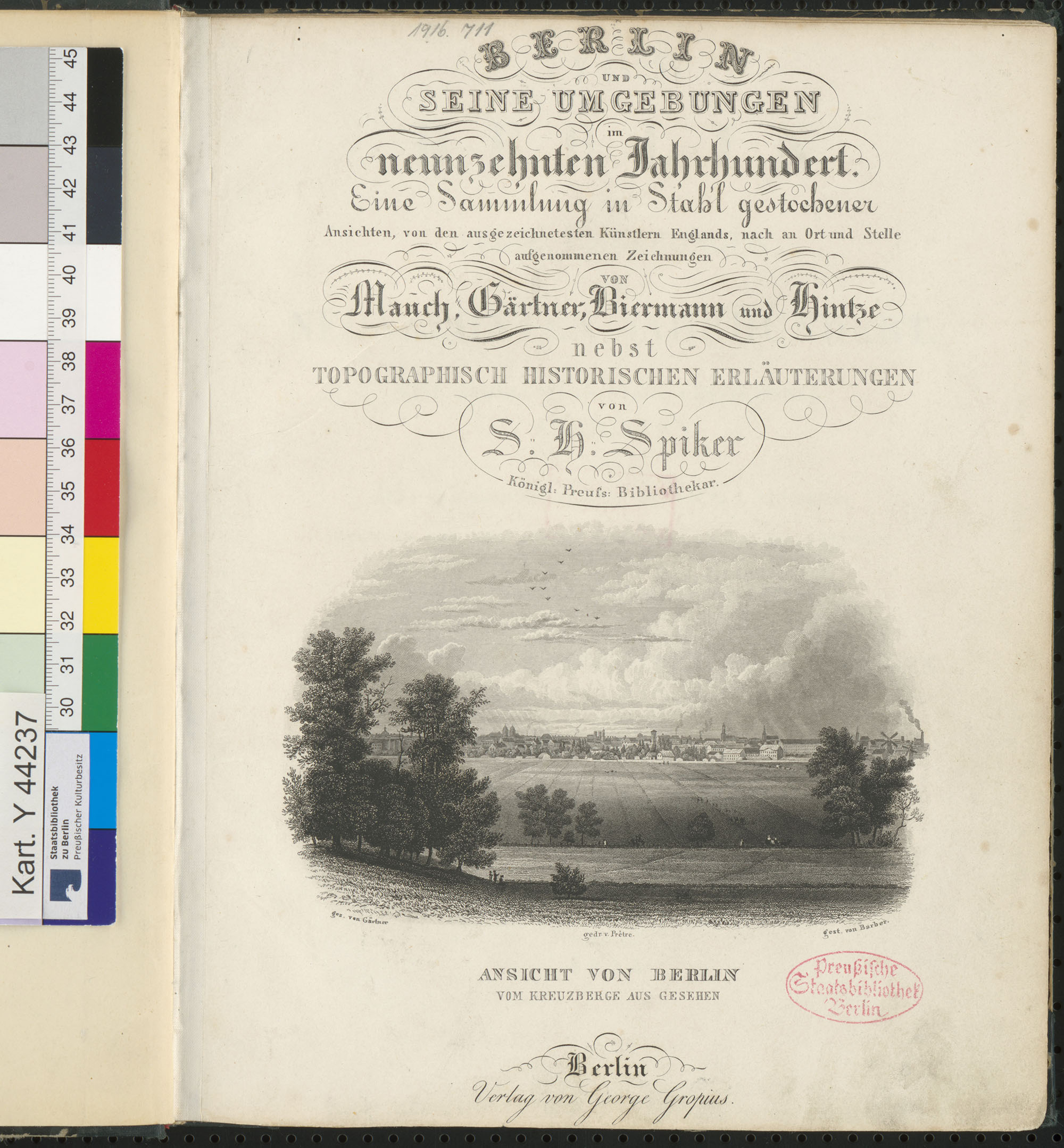
Title page of Berlin und seine Umgebungen im neunzehnten Jahrhundert. Source: Staatsbibliothek zu Berlin - Preußischer Kulturbesitz, Kartenabteilung, Inv. Nr. Kart. Y 44237.
This essay places Spiker’s guide against the backdrop of the larger transformations of Berlin’s city centre in the early nineteenth century. The protagonist is the architect and painter Karl Friedrich Schinkel, whose designs are omnipresent throughout the work. The following three aspects are elucidated: the rejection of baroque town planning in favour of classicist aesthetics, the emerging urban presence of the bourgeoisie and, finally, the representation of the city in the early mass media of pano- and dioramas. The use of oblique views, the portrayal of pedestrians and the fragmentary depictions of buildings each represent the social and political transformations of the decades preceding the guide’s publication. Each of the aspects are first introduced and subsequently related to Spiker’s guide in more detail.
Die Grüne Wiese
In the early nineteenth century, Berlin’s city centre underwent a subtle but profound transformation. Unlike urban renewals in other European cities, which either redefined whole existing neighbourhoods or took place in the open landscape outside disused city walls, Berlin’s transformation took place in the inner city. The protagonist in the urban planning of this period is the architect Karl Friedrich Schinkel (1781–1841). Indeed, he was an ‘architect’ rather than a ‘town planner’, since no comprehensive plan for Berlin’s centre seems to have been made during his lifetime; rather, city planning evolved through a series of small-scale architectural interventions.
Schinkel’s “environmental planning”, as Hermann Pundt has termed it1, has to be understood within the context of larger transformations in art, architecture and urban planning around 1800. These transformations are the subject of the dissertation Spätbarocker und Romantischer Klassizismus (1922) by the Swiss architectural historian and theorist Siegfried Giedion. To explain the transition between a baroque and neoclassical mode of urban planning, Giedion compared two plans for Karlsruhe made in 1787 and 1797.2 The earlier baroque version by Mauritio Pedetti emphasised the coherence of urban space while subordinating individual buildings. The later, neoclassical-inspired version by Friedrich Weinbrenner gives preference to individual, rectangular buildings, which are anchored in an ocean of undefined space. This contrast is further illustrated by the different viewpoints of the artist’s impressions. Pedetti takes a central bird’s eye perspective, while Weinbrenner provides an oblique view of the market. While Pedetti’s view is privileged and absolute, rising above all individual perspectives, Weinbrenner’s is just one of many possible perspectives of a pedestrian at eye level. This change in perspective exemplifies the growing resistance to absolutism and its favoured style: the baroque. Not surprisingly, the French Revolution took place right in between the two plans of Pedetti and Weinbrenner. If social upheaval was not yet the case in Karlsruhe, its message could be passed through in images rather than actions—even if those images were commissioned by the court itself to please its citizens.
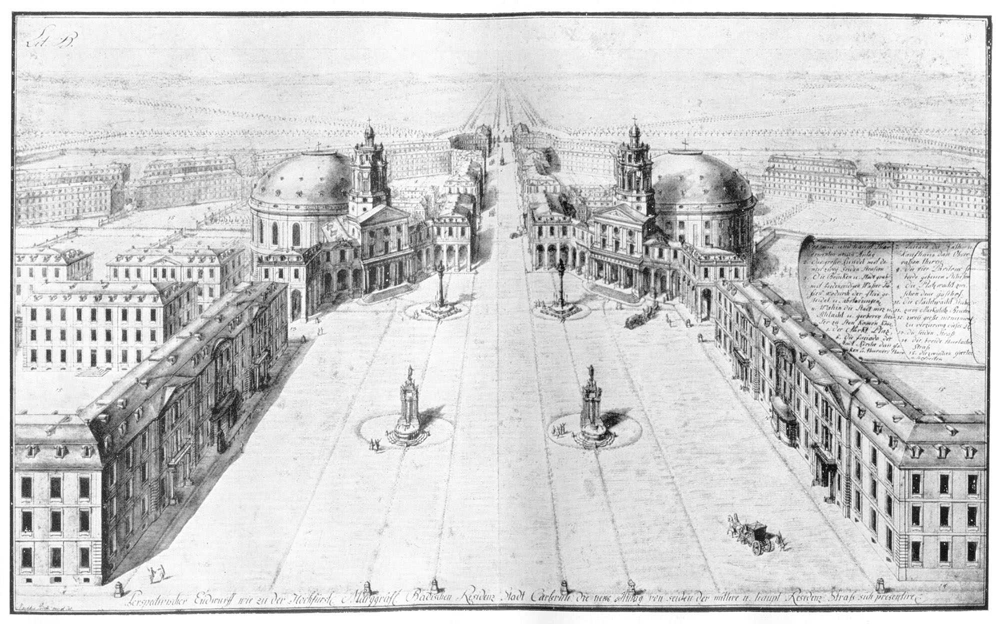
Mauritio Pedetti (1719–1799), central bird’s eye perspective of the design for the Marktplatz in Karlsruhe (1787). Source: S. Giedion, Spätbarocker und romantischer Klassizismus (Munich: F. Bruckmann, 1922).
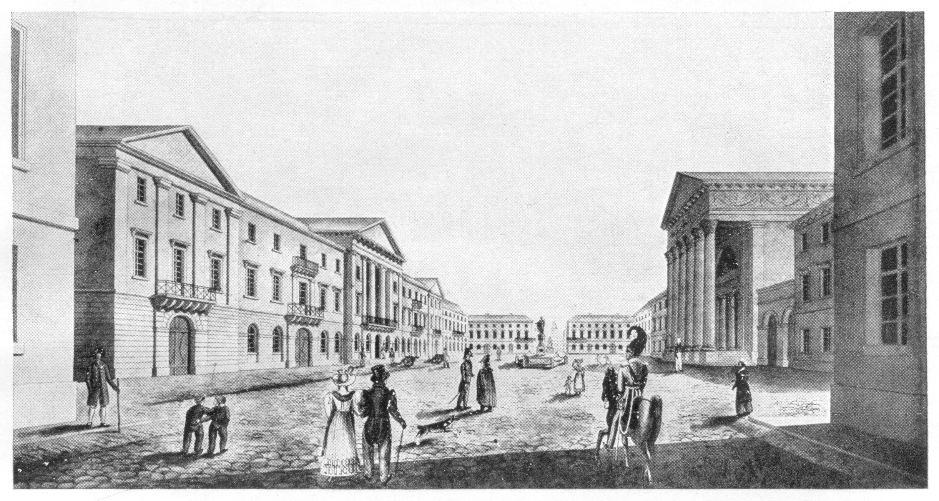
Friedrich Weinbrenner (1766–1826), oblique view of the Marktplatz in Karlsruhe (around 1825). Source: S. Giedion, Spätbarocker und romantischer Klassizismus (Munich: F. Bruckmann, 1922).
In another example, Giedion refers to Leo von Klenze’s planning of the Königsplatz in Munich.3 Here, a set of cultural buildings is connected to the existing city as a projecting satellite. Although somehow in coherence with the existing city plan, the buildings are depicted as if they are completely in the ‘Grüne Wiese’, the undeveloped fields on the outskirts of the city. In Berlin, this tendency toward isolation from the existing urban context is exemplified by Friedrich Gilly’s design for a monument to Frederick the Great at Leipziger Platz (1797). In his famous perspective of the project, which enticed Schinkel to pursue a career in architecture, any direct indication of the existing square is avoided. The bright temple on the artificial acropolis appears as something otherworldly, disconnected from the city’s turmoil and a loophole to another place and time. For Giedion, this signifies the tendency of the Romantic movement to prioritise the individual (and individual parts) over the collective (and the overall composition) and, likewise, transience and contemplation over the continuous movement of the baroque.4
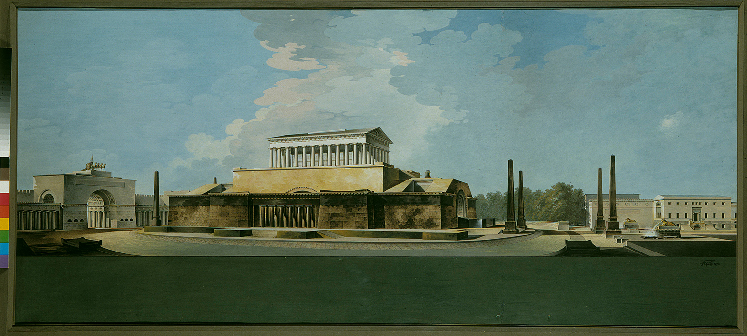
Friedrich Gilly (1772–1800), design for a monument to Frederick the Great at Leipziger Platz in Berlin (1797). Source: Kupferstichkabinett, SMB / Reinhard Saczewski
To be sure, many explanations can be given for this transformation, and its causes and effects proceed far beyond urban planning alone (and the scope of this paper for that matter). Giedion’s comparative method, as adopted from Heinrich Wölfflin, is aimed at emphasising difference, which does not necessarily allow for much nuance. It is, however, useful as a tool or interpretive framework to ‘read’ the images of Schinkel’s Berlin against the backdrop of an overall anti-baroque sentiment, strengthened by the aftermath of the Napoleonic Wars (1803–15). Contrast defines parts more clearly and equally sets the categories for comparison. By taking Giedion’s viewpoint, the images lose their innocence and become foot soldiers on a visual battlefield. They become a medium for political messages which cannot be openly expressed and are therefore ‘passed over in silence,’ to refer to one of Wittgenstein’s propositions in the Tractatus Logico-Philosophicus.
Schinkel’s Berlin
Schinkel’s urban renewal is different from Weinbrenner’s in Karlsruhe or Klenze’s in Munich. Large-scale planning was out of the question in Berlin, if only because of the diffidence and thrift of King Frederick Wilhelm III of Prussia and the city’s distinctive topography. Schinkel’s urban and architectural designs for Berlin’s city centre consist of a series of seemingly independent interventions, which show a surprising consistency upon further consideration. The key problem Schinkel faced was the connection between the Lustgarten, a former pleasure garden of the city palace now used as a parade ground, and Unter den Linden, one of the three main streets of the western extensions leading up to the Brandenburg Gate.5 Between the palace, located in Cölln on an island in the river Spree, and Unter den Linden on the mainland, lay Neu Cölln, an area bordered by a branch of the Spree and the moat of the disused seventeenth-century fortifications. Two narrow bridges connected the three areas and complicated the passage between the different parts of town. Visually, the northwest-oriented rear façade of the city palace did not provide a happy end-point to the prominent east-west axis of Unter den Linden.
Schinkel’s first architectural intervention included covering the old moat and using it as a rainwater drain for the Neue Wache, the new quarters for the royal guard at Unter den Linden. This design shows the ingenuity of combining small-scale architectural projects with urban renewal. Franz Krüger’s painting Parade auf dem Opernplatz in Berlin (1824–30) depicts the result. The Neue Wache is positioned at the right of the canvas opposite to the King, who overlooks the military parade from the left. The painting demonstrates the change in viewpoints as exemplified by the aforementioned two plans for Karlsruhe: it offers an oblique view of the parade, different from the privileged view of the King. The parade, which seems central to the painting, is in fact background material. More prominent is the crowd assembled around Schinkel’s guardhouse at the bottom right. Rather than anonymous onlookers, this area presents a collective portrait of the city’s emerging cultural elite. Writers, actors, singers and sculptors are depicted and even Schinkel himself is included, looking the viewer straight in the eye. The painting depicts the paradigm shift from the collective parade of the military troops to the individual parade of the flâneur. The penetrating gazes of the crowd pull the viewer into their midst against the backdrop of Schinkel’s guardhouse, a fresh piece of urban scenery accompanying the appearance of the bourgeoisie.
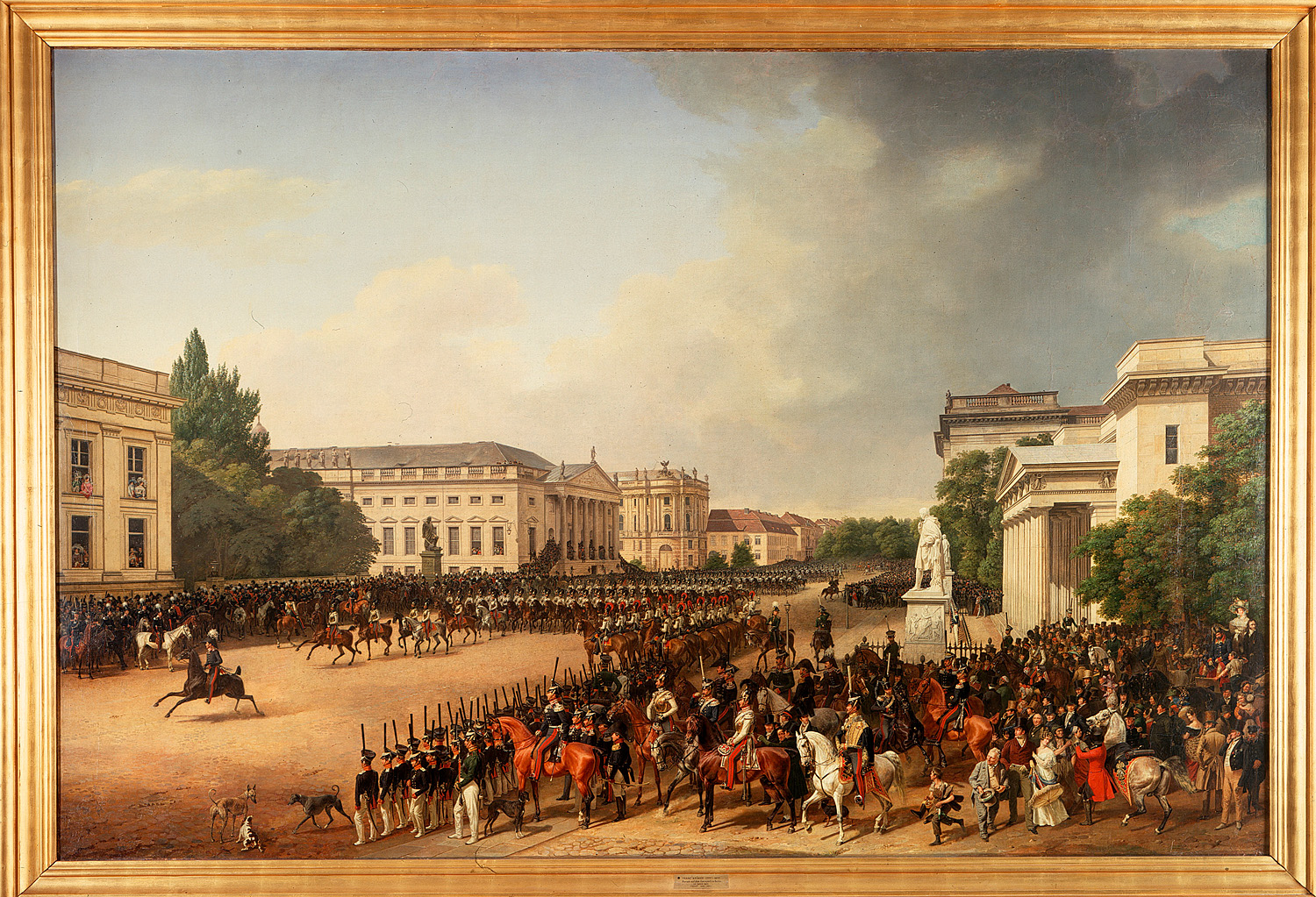
Franz Krüger (1797–1857), Parade auf dem Opernplatz in Berlin (1824–1830). Source: Nationalgalerie, SMB / Klaus Göken
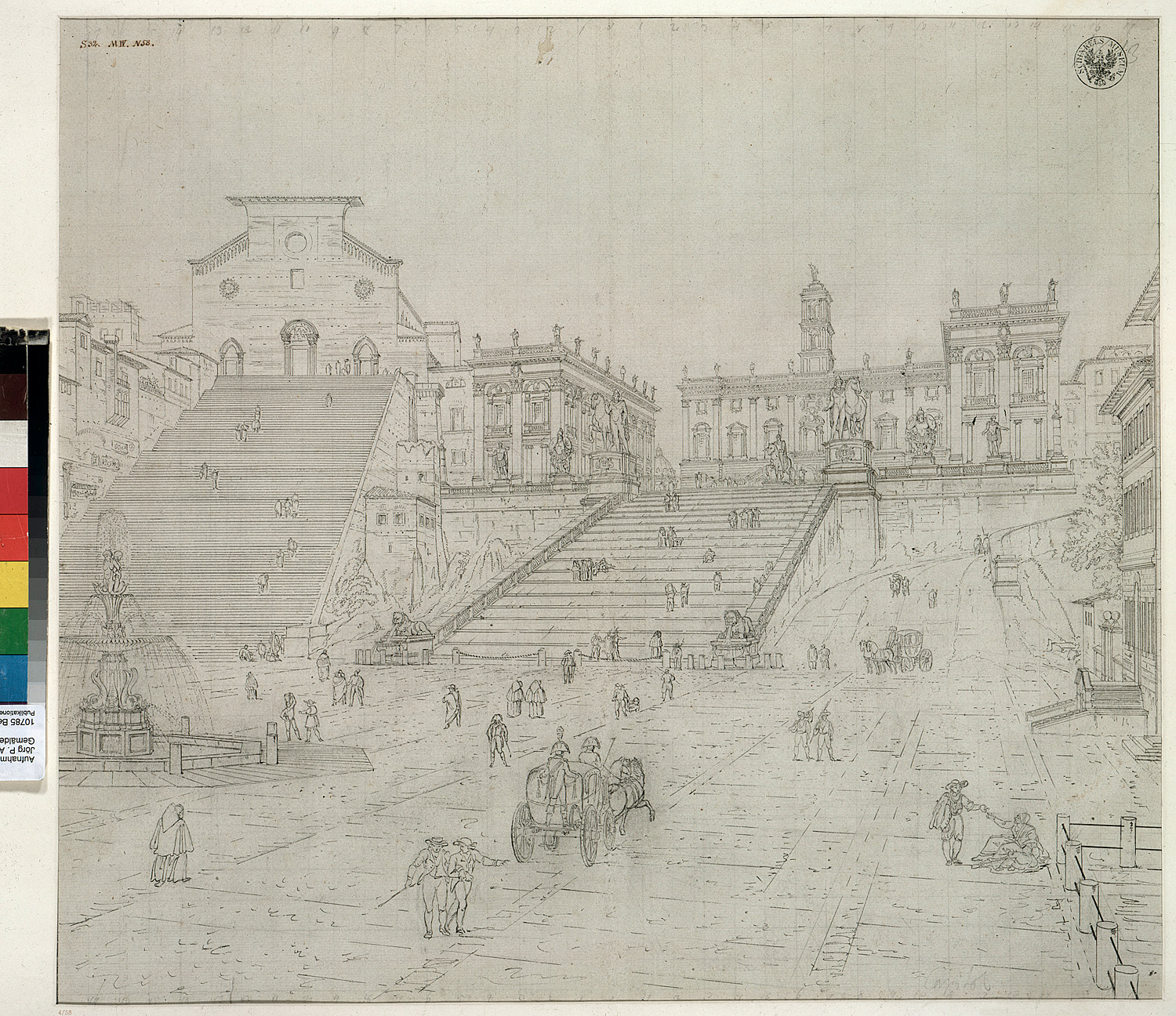
Other projects by Schinkel around the Lustgarten were planned in similar ways. The Altes Museum was also built on a filled-in canal, which used to give access to the warehouses at the Werderscher Markt. Due to the museum’s construction, the warehouses were moved north and housed in new buildings designed by Schinkel.6 The site of the old warehouses, at the Werderscher Markt, was eventually occupied by Schinkel’s Bauakademie. The perspective drawings of these designs around the Lustgarten all depict seemingly isolated and self-contained buildings in an open landscape, reminiscent of Gilly’s memorial and Klenze’s Königsplatz. In the case of the Altes Museum, a row of trees was planted on the east side of the Lustgarten in order to disconnect the museum from the adjacent stock exchange and the side-wings of the cathedral, leaving visible only the cathedral’s newly renovated front—needless to say, also designed by Schinkel. On the interior perspective of the museum looking out over the Lustgarten and its surroundings, neither the city palace or the Zeughaus play an important part. Rather, the now-vacant site of the old warehouses is central to the view, anticipating the next step and visually connecting the different locations of Schinkel’s designs.
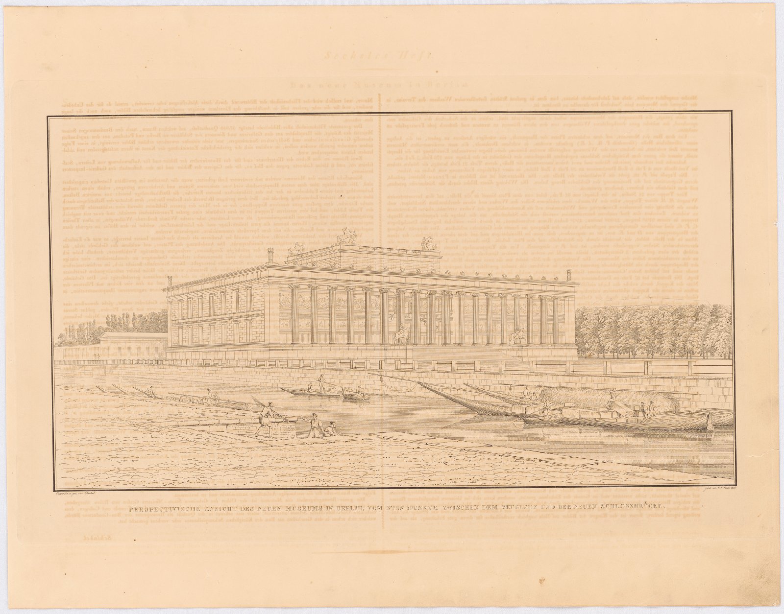
Karl Friedrich Schinkel (1781–1841), perspective drawing of the Altes Museum’s exterior (1858). Source: Architekturmuseum TU Berlin, Inv. Nr. SAE 1858,037.
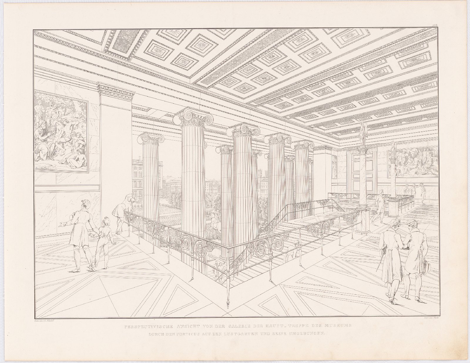
Karl Friedrich Schinkel (1781 - 1841), perspective drawing of the Altes Museum’s interior staircase (1858). Source: Architekturmuseum TU Berlin, Inv. Nr. SAE 1858,103.
Although contrasting in both function and style, all designs are part of a greater plan, in which ‘old’ and ‘new’ change places, like pieces on a chess board. What seems to connect these individual operations is an effort to hide or transform the existing city while introducing a new series of otherworldly and interconnected architectural interventions.
Panorama and Diorama
A key to understanding the visual representation of his designs, is Schinkel’s painterly career. During his entire life, but particularly before the end of the Napoleonic Wars in 1815, Schinkel worked as a painter of traditional canvases, set designs for the Royal Opera House and the emerging mass media of pano- and dioramas. After returning from his first trip to Italy in 1805, he presented dioramic paintings depicting sights from the Grand Tour, which he exhibited at the yearly Christmas markets.7 Like panoramas, these paintings, called ‘perspective optical views’ by Schinkel himself, challenged the existing conception of viewing a work of art by eliminating its direct context. In panorama buildings, visitors were led through a dark tunnel before entering a bright platform in the centre of the circular painting. The borders of the canvas were hidden from sight by an artificial landscape extending from the viewing platform and a covering canopy. In the case of dioramas, viewers were led into a dark auditorium in which an illuminated canvas appeared together with musical accompaniment; a setting similar to present-day movie theatres.
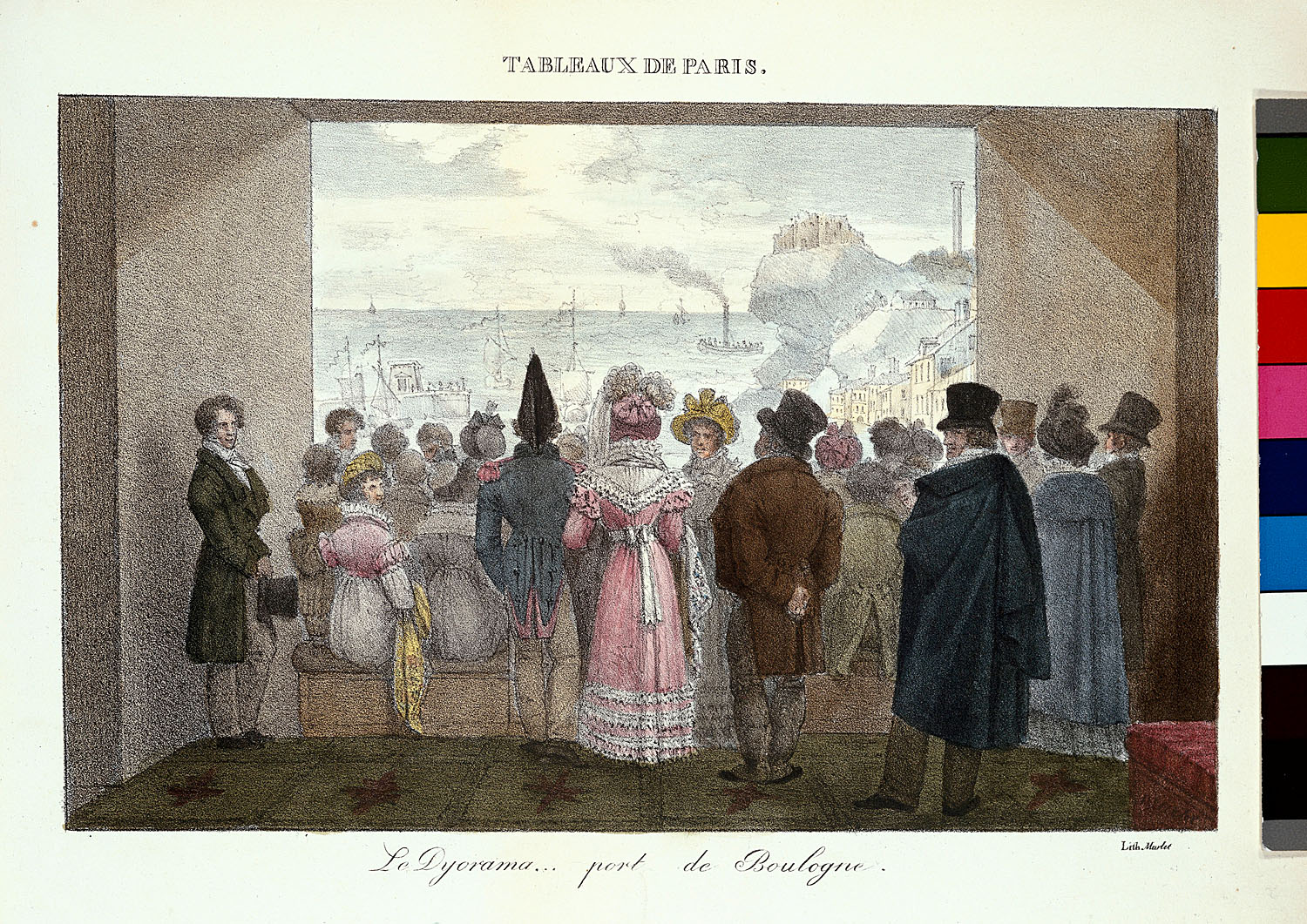
Jean Henri Marlet (1771 - 1847), showing of a diorama in Paris (1821-23). Source: Kunstbibliothek, SMB / Knud Petersen
In his buildings, Schinkel re-created parts of the experience of entering a pano- or diorama. In the Schauspielhaus at the Gendarmenmarkt, visitors entered on the ground floor, moving through a maze of rooms without daylight before ascending to the bright auditorium.8 Similarly, the design for the open staircase of the Altes Museum was altered to lead visitors through a dark flight of stairs before entering the bright platform.9 While the pano- and dioramas staged the painted prospects by hiding the outside world, Schinkel’s architectural designs first disoriented visitors to then present the surroundings from a brand new perspective. The buildings recreated an experience similar to leaving a (movie) theatre, when reality seems enchanted by a continuation of the fiction of the play or film seen just minutes before.
Dioramas, more often than panoramas, depicted distant sites, serving as a substitute for expensive and dangerous travel.10 They offered their audiences a new prospect within the comfort zone of their own city and without the need to interact (or be threatened by) the depicted events directly. This provides another parallel to Schinkel’s architectural designs. Buildings like the Altes Museum, both in form and content, aimed to draw the distant past of ancient Greece and Rome into the midst of Berlin. By first disconnecting from the existing city and its outmoded baroque architecture, the buildings then introduced a distance, both in place and time, which profoundly contrasted with the local surroundings. These new travel destinations in the midst of the city aimed to offer new models for Berlin and its citizens to measure up to.11
Karl Friedrich Schinkel (1781 - 1841), Sketch for a diorama of the Capitoline Hill in Rome. Source: Kupferstichkabinett, SMB / Jörg P. Anders
From the perspective of Schinkel’s painterly career, his built work in Berlin’s city centre reads like a set of endless landscape cards: a series of individually distinct buildings surrounded by a seemingly open and homogeneous landscape, together forming a continuous chain. Or, to relate it to his paintings, a set of dioramas combined into a single panorama. Two Schinkel-designed tables produced by the Royal Porcelain Manufactory best illustrates this. On the tabletops, oblique views of most of Schinkel’s designs are juxtaposed in a circular composition, together forming a complete—but actually fragmentary—image of the city’s main sights. It recalls contemporary postcards that represent the city by a collage of different sights, rather than a single view.
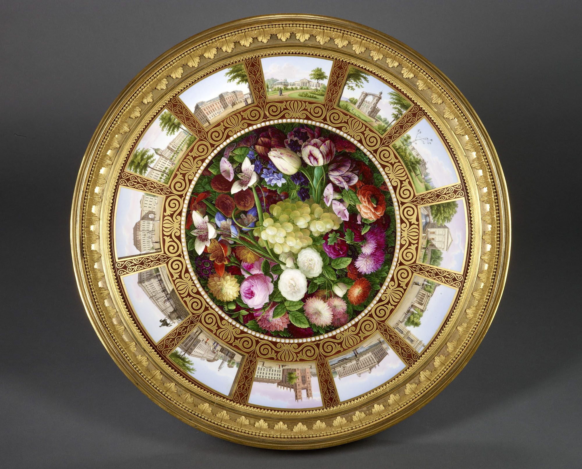
Karl Friedrich Schinkel (1781 - 1841), porcelain tabletop produced by the Royal Porcelain Manufactory (1830). Stiftung Preußische Schlösser und Gärten Berlin-Brandenburg, In. Nr. IV 30. Photo: Wolfgang Pfauder.
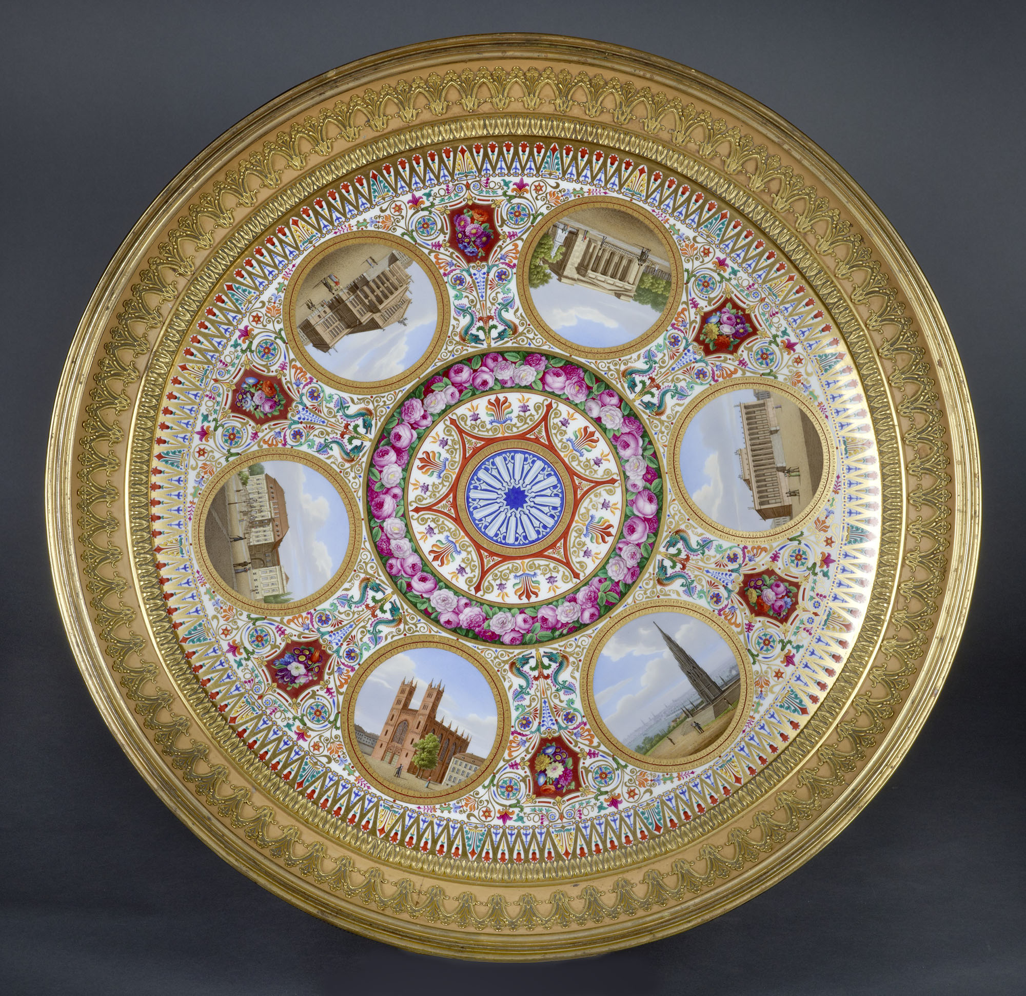
Karl Friedrich Schinkel (1781 - 1841), porcelain tabletop produced by the Royal Porcelain Manufactory. Stiftung Preußische Schlösser und Gärten Berlin-Brandenburg, In. Nr. IV 30. Photo: Wolfgang Pfauder.
Spiker’s Guide to Berlin
Most of the buildings depicted on the tabletops are also featured in Berlin und seine Umgebungen im neunzehnten Jahrhundert, the 1833 guide to Berlin written by the journalist, travel writer and librarian Samuel Heinrich Spiker (1786–1858). This text is considered to represent the height of the illustrated guides of the Biedermeier period and is seen as a valuable source due to the combination of text and images.12 Earlier late-eighteenth-century guides, like Friedrich Nicolai’s 1779 Beschreibung der königlichen Residenzstädte Berlin und Potsdam, lacked illustrations, while previous series of engravings, like those from Johann Georg Rosenberg around 1780, were sold as separate entities without an accompanying publication.
Spiker’s guide expresses the three different contexts to Berlin’s urban transformations in the early-nineteenth century, outlined above: (1) the romantic rejection of the baroque, (2) the presentation of the emerging bourgeoisie in Berlin’s public space and (3) the experience of early mass media like panoramas and dioramas. Each of these aspects is further expounded:
1.) Most views in Spiker’s guide are taken at eye level from an oblique angle. Only church interiors are shown in one-point perspective. Some exteriors are shown en face, but only when the natural or urban context adds enough asymmetry to compensate for the regularity of the façade. This reduces the visual effect of the depicted baroque palaces and town houses, which benefit from a central perspective. As an example, in the engraving of the Radzivilsche Palais, the oblique view causes the side wings to cover the front façade, thereby reducing the visual depth of the forecourt. In other cases, parts of important baroque buildings were simply omitted. In the case of Schloss Monbijou, the view shows the late-eighteenth-century entrance gate and does not include the main complex, while the text highlights the surrounding English landscape garden.13 The façade of the Königliche Bibliothek at the Platz am Opernhaus (Bebelplatz) is partly covered by two trees, overemphasising the existing greenery. In the case of the Masonic Lodge Royale-York (housed in Andreas Schlüter’s Villa Kamecke), the oblique view flattens the convex and concave curves of the façade and counters the centrifugal force of the group of roof statues—despite the praise for the design in the accompanying text.14
Das Gräflich Redernsche Palais serves best as a counterexample. This baroque town palace at the Pariser Platz was remodelled by Schinkel in the style of a Florentine palazzo. An upright decorated cornice, concealing the sloping roof behind, took the place of the existing Mansard roof. As Giedion noted, none of the side façades of the renovated palace are symmetrical in themselves; the tall arched windows on the sides lack a proper counterpart where the two sides meet. It is only when approached from an oblique angle that the view is symmetrical and is completed by the coat of arms at the corner of the building.15 This is the view offered in Spiker’s guide, after Schinkel’s own perspective drawings of the building. In the engraving, trees fall over the adjacent buildings on the left, while the still-visible pitched roof on the right allows for the sun to illuminate the west façade. In this way, the existing surroundings are left in the dark and become visually subservient to the palace, which projects forward to the square and seems to be at the centre of it—although actually located in one of its corners.
2.) The selection of sites for the guide mirrors the interests of the emerging bourgeoisie. Royal palaces, churches and other highlights alternate with all kinds of public and private institutions, industrial buildings and places of entertainment. For example, the palace of Prince Charles of Prussia is shown beneath an engraving of the recently inaugurated gasworks. Almost none of the images depict military troops or parades like the one on Krüger’s painting. The streets on the engravings are populated with labourers, merchants, flâneurs and aristocrats accompanied by an occasional guard.
Among the places for entertainment listed in the guide are the diorama building and the adjacent studio of the Gropius brothers. The inclusion of these places is not coincidental. The guide was published by George Gropius (1802–42), who founded the diorama together with his brothers Carl and Ferdinand in 1827. As well as providing for the display of dioramic paintings, the diorama functioned in its early years as a tourist office for visitors, selling artworks by local artists and all kinds of publications and other printed matter related to Prussia’s capital city.16 Adjacent to the building was the painting studio of the Gropius brothers, which obtained a separate entry in the guide.
Other advertisements for the Gropius brothers appear throughout the guide. In an engraving of the Königliche Opernhaus, a pedestrian is looking at an advertisement for Gropius’s diorama mounted on a tree.17 The art- and bookshop of George Gropius is featured on an engraving of the Stechbahn, opposite to the Stadtschloss. The publishing company, housed in the diorama until 1831, took office on the ground floor of the Bauakademie and is mentioned in the description of that building.18 These advertisements place the private companies of the Gropius family on an equal footing with Berlin’s public monuments. In the guide, as well as on the streets of Berlin, the growing middle class made its appearance and challenged the existing status quo.
3.) The guide itself is part of a dialectic between an interest in the distant and unknown, and the effort to restructure and reimagine the immediate surroundings. Samuel Spiker, before writing the guide, published a journal of his travels to the United Kingdom and translated works by Shakespeare and Walter Scott, earning the nickname ‘Lord Spiker’19 In the same manner, the Gropius diorama, combining distant and immediate views, functioned as both a travel agency and a local tourist office.
On the engravings, the city’s public monuments are staged in a way comparable to the depiction of ancient remains in archaeological publications. They are shown as fragments of a greater entity, waiting to be fully discovered by the first mass tourists. Other than providing a full picture, the engravings draw the readers’ interest by remaining incomplete: the oblique views by definition result in overlapping fragments and show just one of many possible standpoints. The scale and effect of the images are adjusted by the subsequent arrangement of front and back, application of chiaroscuro and placement of the greenery and figures on the street. While seemingly objective, the images are in fact heavily manipulated in order to present a specific ideal of Prussia’s emerging capital city, borrowing from the techniques of dioramic painting.
Conclusion
The engravings in Spiker’s guide still cast a spell on contemporary Berlin. Even after most of the buildings have disappeared in their original form, the standpoints, frames and compositions continue to play a role in the reconstruction of the city centre after the fall of the Berlin Wall. Images of buildings have erupted on large canvasses stretched against temporary scaffoldings, like Schinkel’s Bauakademie or the Stadtschloss before its current reconstruction. In light of the former, is it a coincidence that the single reconstructed corner of the Bauakademie actually used to house George Gropius’s publisher , where Spiker’s guide was put together? It is at least symbolic for the fact that after almost two centuries, the guide itself has come to serve as an ideal image for the reconstruction of the city. This ideal, however, is grounded in the unique historical conditions of the years following the Napoleonic Wars and the establishment of new visual, if not always political, regimes.
This essay resulted from a presentation at the 2016 Books and the City conference in Maastricht, The Netherlands, organised by Maastricht University and the Jan van Eyck academie.
Footnotes
H. G. Pundt, “K. F. Schinkel’s Environmental Planning of Central Berlin”, Journal of the Society of Architectural Historians 26, no. 2 (1967): 114–30. ↩
S. Giedion, Spätbarocker und romantischer Klassizismus (Munich: F. Bruckmann, 1922), 156–62. ↩
Ibid., 124–5 and 162–3. ↩
Ibid., 12–13. ↩
H. G. Pundt, Schinkel’s Berlin (Frankfurt: Propyläen Verlag, 1981), 17–47. ↩
K. F. Schinkel, Sammlung Architektonischer Entwürfe (Nördlingen: Verlag Dr. Alfons Uhl, 2006), 12–18. ↩
B. Verwiebe, “Schinkel’s Perspective Optical Views: Art between Painting and Theatre”, in Karl Friedrich Schinkel: The Drama of Architecture, ed. J. Zukowsky (Tübingen: Ernst Wasmuth Verlag), 36–7. ↩
J. Brauns, ‘Schauplätze’ Untersuchungen zur Theorie und Geschichte der Dispositive visueller Medien (Weimar: Bauhaus-Universität Weimar, 2003), 215–16. ↩
C. M. Vogtherr, “Das Königliche Museum zu Berlin: Planungen und Konzeption des ertsten Berliner Kunstmuseums”, Jahrbuch der Berliner Museen 39, supplement, 127. ↩
H. Buddemeier, Panorama, Diorama, Photographie: Entstehung und Wirkung neuer Medien im 19. Jarhhundert (Munich: Willem Fink Verlag, 1970), 41–2. ↩
Vogtherr, Das Königliche Museum zu Berlin, 127. ↩
A. Teltow, “Berlin in der grafischen Darstellung bis 1870. Versuch einer Annäherung”, in Die Stadt Berlin in der Druckgrafik 1570–1870. Band 1, ed. G. Ernst (Berlin: Lukas, 2009), 81. ↩
S. H. Spiker, Berlin und seine Umgebungen im neunzehnten Jahrhundert (Leipzig: Zentralantiqauriat der Deutschen Demokratischen Republik, 1974), 84–5. ↩
Ibid., 75–6. ↩
Giedion, Spätbarocker, 122. ↩
Spiker, Berlin und seine Umgebungen, 47–8. See also: E. Stenger, Daguerres Diorama in Berlin: ein Beitrag zur Vorgeschichte der Photographie (Berlin: Union Deutsche Verlagsgesellschaft, 1925). ↩
A similar advertisement has also been noted by Birgit Verwiebe in a painting by Wilhelm Brücke. See: B. Verwiebe, “Panorama, Diorama und die ‘Linden’”, in Unter den Linden: Berlins Boulevard in Ansichten von Schinkel, Gaertner und Menzel (Berlin: G-und-H-Verlag, 1997), 44. ↩
Spiker, Berlin und seine Umgebungen, 119–21. See also: R. Gropius Genealogie der Familie Gropius (Görlitz: Starke, 1919). ↩
P. Clive, Beethoven and his World: A Biographical Dictionary (Oxford: Oxford University Press, 2001), 345. ↩